Analysis of 2026 heatwaves UK
By: Simon Brooke :: 4 August 2026
Edited 13th August to add: This essay is misleading and alarmist. It was written in good faith, but I have since researched and done the maths to more fully explore the probable wet bulb temperatures given the Met Office's scenario, and my assumptions were wrong. This work is documented here.
A note on isobar charts linked from this essay: these are screen-shotted from digital.nmla.metoffice.gov.uk, which is where the Met Office serves historical data. I have chosen the isobar charts from midday of each day discussed, for comparability.
In their projection of a heatwave in 2056, the Met Office projected a southerly airflow bringing warm air from France and Spain. That implies high pressure over the Mediterranean ridging north across Switzerland towards Germany, and relatively low pressure in the Atlantic over sea areas Trafalgar, Fitzroy, Sole, Fastnet. That's perfectly plausible. But it's significant because, coming over land, this is dry air, and dry air is relatively safe. Moist, humid air, off the sea, is much more dangerous.
So how likely is it that a 45° Celsius heatwave would be dry?
May
We've already had a number of heatwaves this year. The first started on 22nd May and ran until the 31st — ten days inclusive.
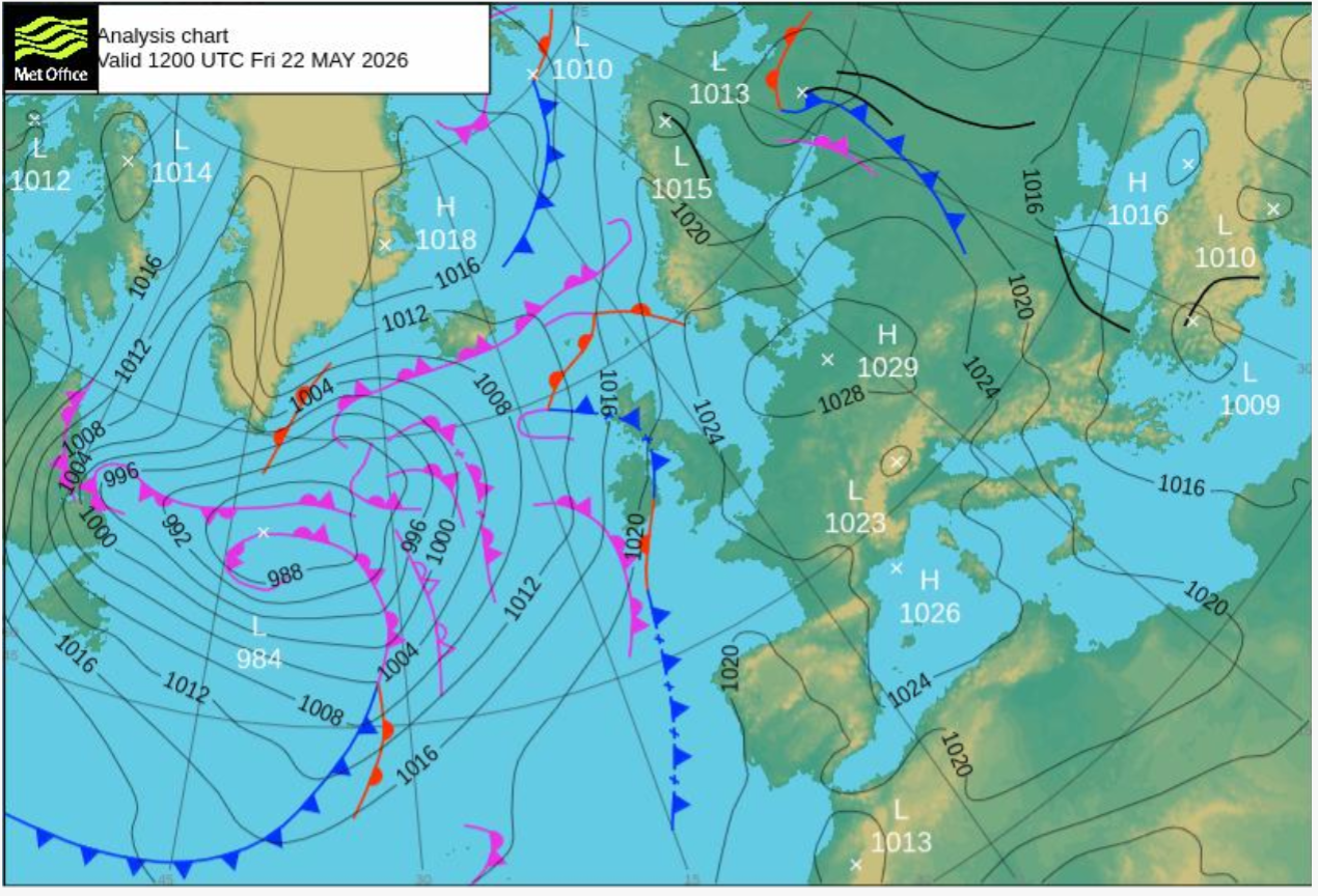
As you can see, there's a south westerly airflow — off the Atlantic — covering the whole of the British isles. By the 24th, the centre of the high has drifted over the southern North Sea, leading to an easterly (drier) airflow over Devon and Cornwall, but the airflow over the rest of Britain remains westerly. By the 27th it has drifted north and is centred about 150 miles east of Aberdeen, leading to a south easterly airflow over most of the island, but off the North Sea.
The peak of the heatwave was on the 26th, with a shallow high centred west of the Hebrides, which implies that there was no very strong airflow over Britain.
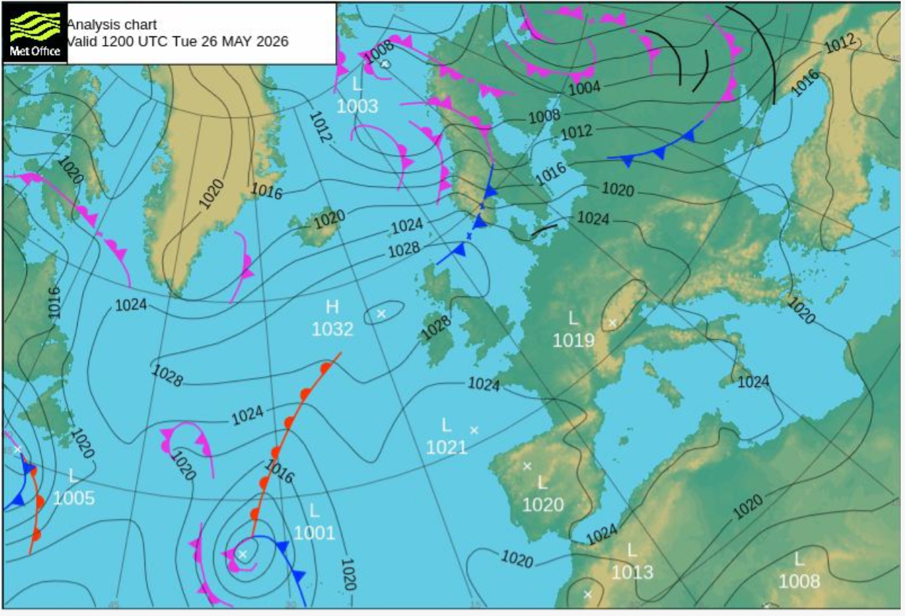
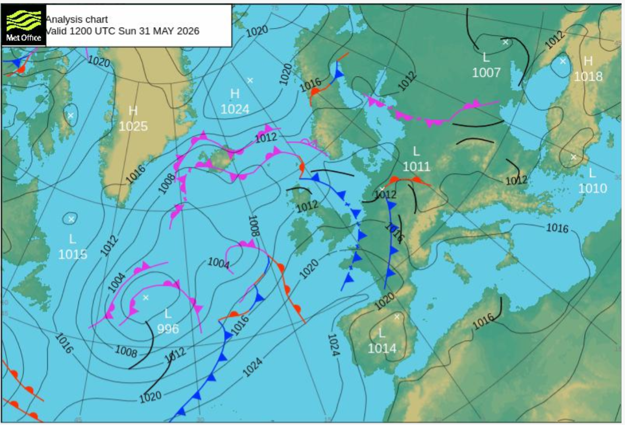
By the 31st, as the heatwave officially ends, the westerly airflow is reestablished, although not especially strong:
June
The June heatwave started on the 19th and ran until the 28th (again, ten days inclusive). Again, there's a strong south westerly air stream across the British isles as the heatwave starts:

Weather diary for the day comments:
Dewpoints of 16°C in warm sector and 20°C at Shoeburyness. There’s quite a strong SW’ly running ahead of the cold front across the North and Irish Seas.
There was a +10° C temperature anomaly affecting the whole of Essex (including Shoeburyness) that day. A 20° C dewpoint is not in itself dangerous; but that's on an absolute air temperature of 32° C. The MetOffice projects a 39° C air temperature for Essex in their scenario; I'm not sure how that translates into dewpoint giving the sort of water burden we might expect, but it probably isn't dangerous to healthy adults.
By the 26th the weather diary is commenting on 'very intense humidity', but I have not found a publicly available isobar chart for this day.
On the 28th the wind is still westerly across the whole of Britain, off the Atlantic, driven by a low about 400 miles north west of Scotland:

July
There was a heatwave from the 6th to the 26th July (21 days inclusive), and another from the 28th to the 30th
The first starts as an absolutely standard Azores High heatwave, with high pressure to the south west of Britain and low pressure to the north, leading to a westerly air stream across the whole country by July 4th:

July 6th, when the heatwave officially starts, confirms this, with the westerly band neatly squeezed between the Azores High and the Iceland Low:
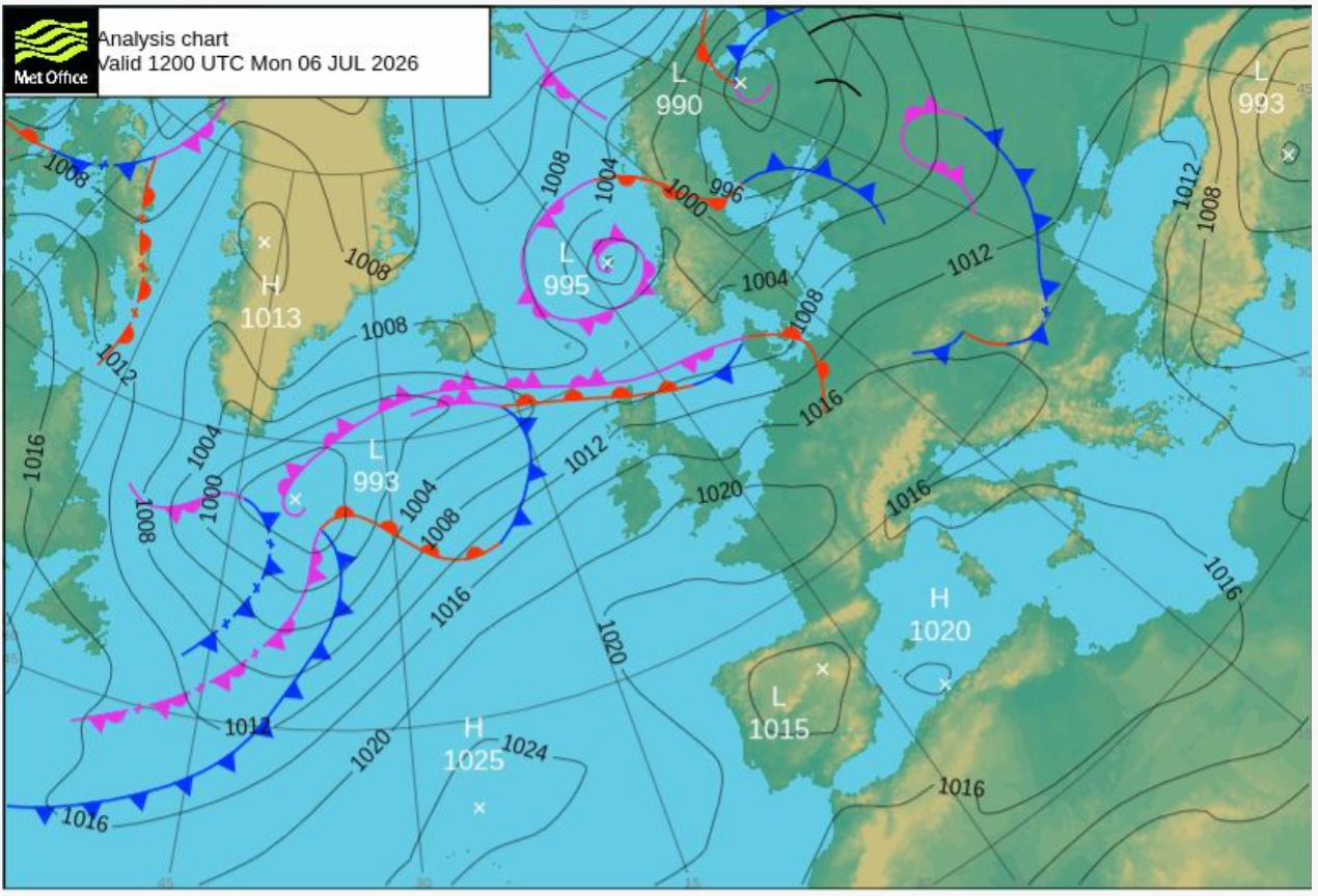
By the12th we see a different pattern: a tight isolated high centred near Fair Isle, with a band of lows from the Azores to the western Mediteranean, leading to a broadly south easterly flow over England, but bringing in air mostly off the North Sea.
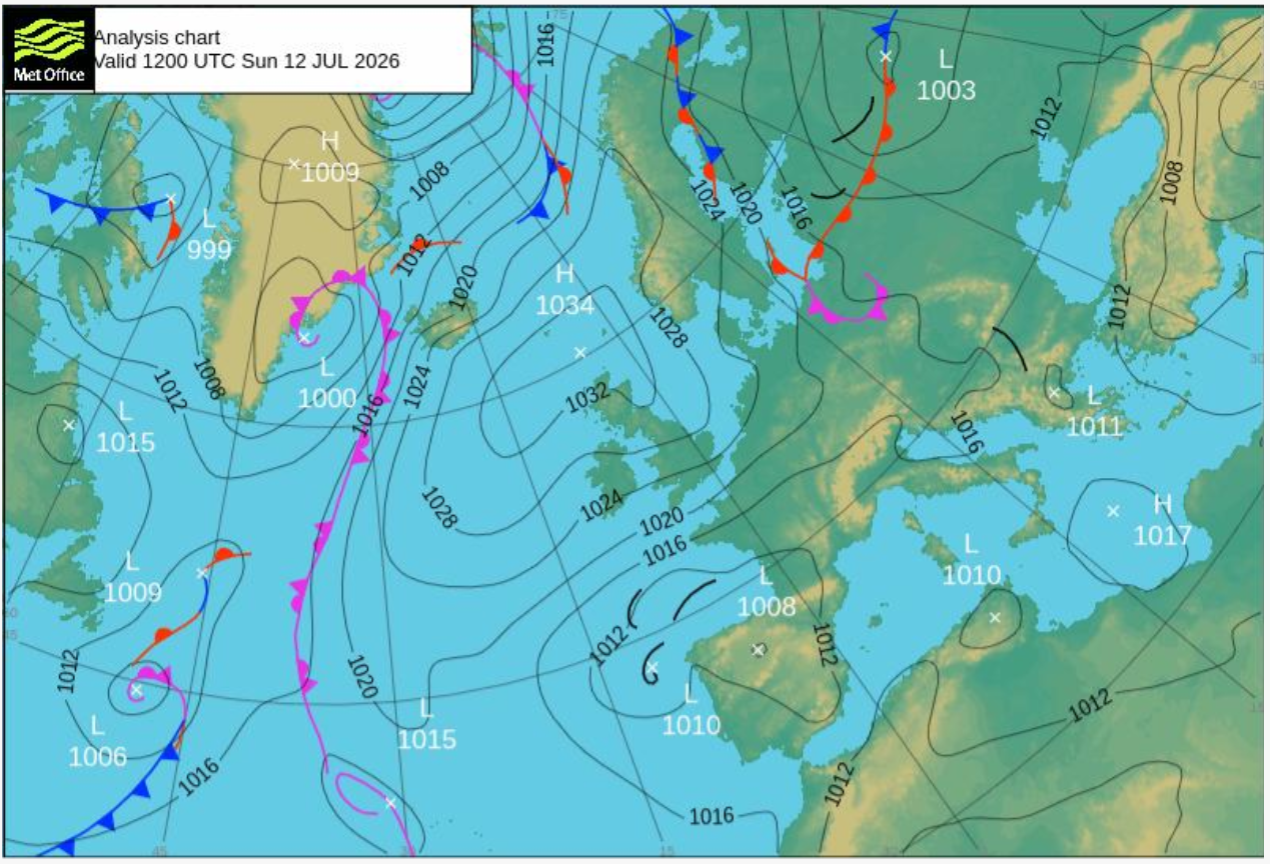
By the 18th it's changed again; now there's a high in the central North Atlantic, centred about a thousand miles west of Scotland, and a low over the Baltic. Between them, there's a northerly airflow across the British Isles, bringing air down off the Norwegian coast:
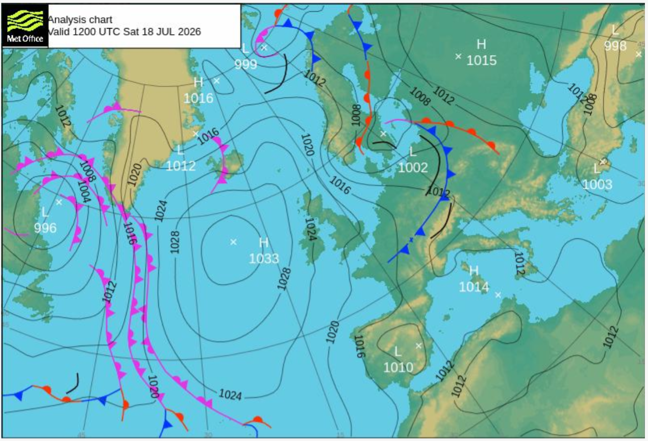
And by the 24th, as the heatwave is reaching its end, we're back to a high centred near (west of) the Azores and a low centred near (north-east of) Iceland, re-establishing the prevailing westerly flow.
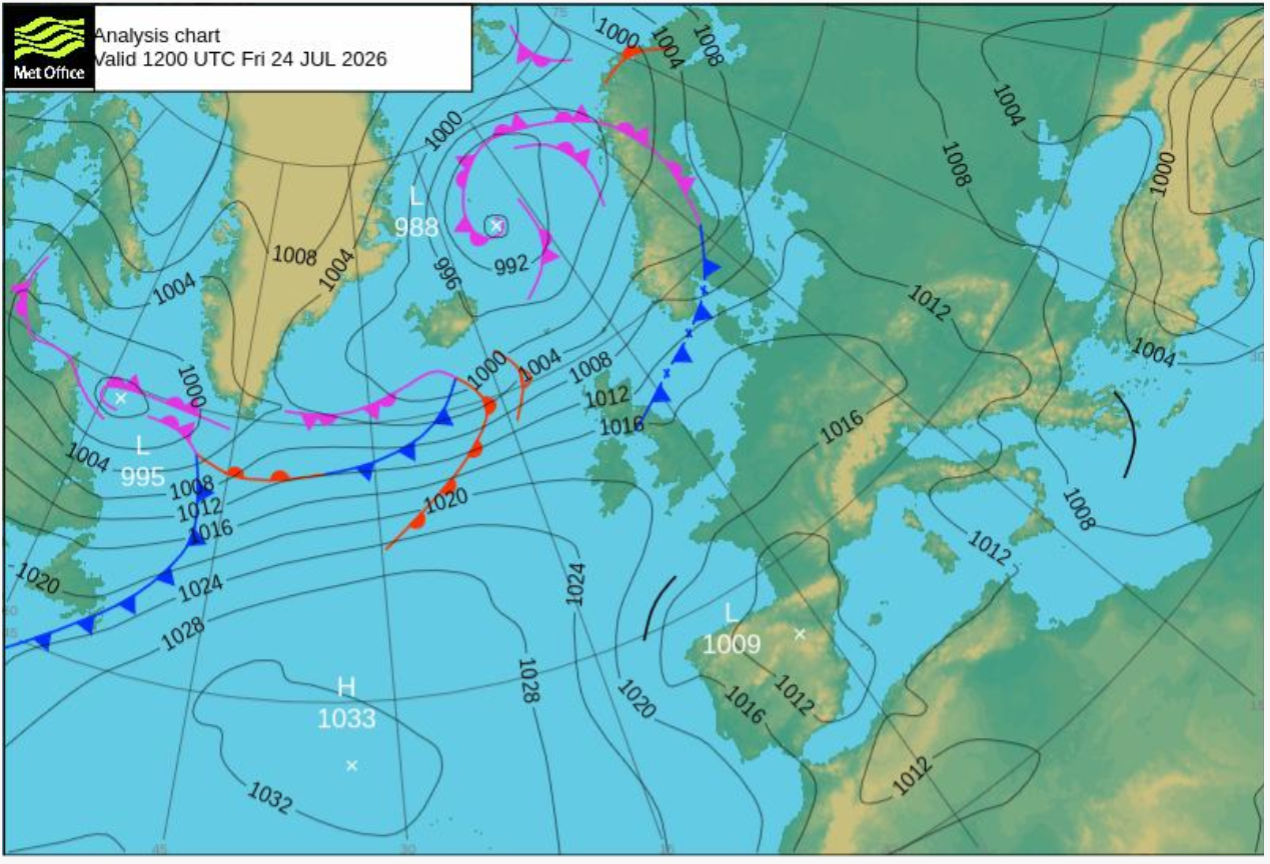
I wish I had the computer resources to put together a movie showing these weather systems moving across the map. I don't. But in the snapshots I have examined, at no point in the May, June or July heatwaves did we have a southerly or southeasterly airflow bringing hot dry air off the European continent. On the contrary, they all start in conditions of steady westerly airflow off the Atlantic, bringing moist air off a warm sea.
August
The August heatwave is current, from the 2nd and continuing now (written on the 4th. It started with high pressure ridging out from Germany over Scotland, with a consequently easterly (dryer) airflow over much of England, although this is fairly light and variable, partly masked by sea breezes:

By today, that ridge has drifted north, leaving what looks like fairly calm air over much of southern England but an easterly airflow, which here in the south is moderate but further north is probably stronger, over Scotland:
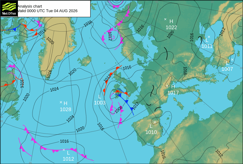
There's a southerly airflow out to the west, which may bring in warmer, damper weather later in the week
And indeed — because I did not finish this essay as quickly as I'd hoped — it's clear that this 'heat wave' is already over by the 6th August, leading me to doubt whether it can be classed as a heat wave at all. However, if this period did count as a heatwave, then it did indeed start with warm air from the continent. But that pattern didn't last.
Edited 10th to add
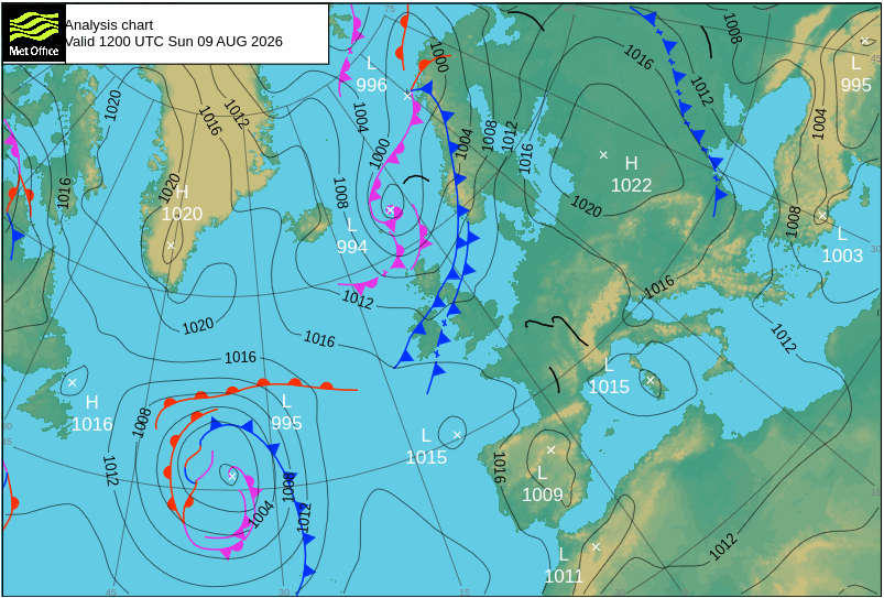
A fifth heatwave has been declared by the Met Office today. Again, we have a westerly airflow rotating a low pressure area near Faroe. This is yesterday's chart, today's has not yet been issued.
Why does any of this matter?
Hot dry air is relatively safe, provided you have enough to drink. Hot humid air is much more dangerous. I've been over this before in The everyone dies event class and in The 'everyone dies' event comes home. The Met Office are projecting 45° C temperatures for June 2056; this is (obviously) not a forecast, but it is a projection from their data and their knowledge — both obviously vastly greater than mine — of what may reasonably be expected to happen.
Given currently normal UK levels of summer humidity, such temperatures would be fatal to any human exposed to it. We wouldn't have 'currently normal UK levels of summer humidity', because relative humidity, which is what matters, reduces non-linearly as temperature rises. But it does not rise all that much, and, if we had warm onshore winds — winds off the Atlantic — in such an event, we would still be very much in the danger zone (how much so, I'm still trying to compute.)
The Met Office claim that their projection would not be an 'everyone dies' event in part because they had projected an airflow via Iberia and France, coming in over land and consequently drier. The question I am asking myself is, is this dry overland likely? Can a wet, maritime airflow be reasonably ruled out?
Inductive reasoning does not work when everything changes
As humans, we are conditioned to anticipate that the future will be very like the past. Because the sun rose yesterday and the day before, we expect the sun to rise tomorrow. That is partly why it's so hard to move the political dial on climate change: our politicians, who are mostly not mathematically literate people, cannot conceive that our weather could get hot enough to cause mass deaths.
I have myself been using inductive reasoning in this essay. What I've shown is that still in 2026, as throughout my lifetime, hot weather in the UK is often — normally — associated with a moist maritime westerly airflow.
But when everything changes, inductive reasoning breaks down. And everything is changing, because the atmosphere is heating, and because melt ice from Greenland and the Arctic is making the surface waters of the north Atlantic less saline, leading to a slowing and probable halt to the Atlantic Meridional Overturning Circulation.
Our hot weather is associated by westerlies because, given the temperature and atmospheric circulation patterns that we have had, a large stable high centred over the Azores and tending to ridge north east has been a recurring feature; and low pressure systems over Iceland, driven eastward by the jetstream, have also been a recurring feature. The westerly airflow is thus not only or even mainly a coriolis airflow, but is accelerated by the clockwise gyre of the Azores High intermeshing with the anticlockwise gyre of the Iceland lows to form a vast supercharger.
The changes to the atmospheric circulation and to the oceanic circulation may break this pattern. The jetstream is already much more chaotic, making deeper loops across the north Atlantic, upsetting the tracks of the low pressure systems that used to form a (relatively) neat and orderly crocodile. And the Azores High has never been as stable as Jupiter's Great Red Spot; rather, it's come and gone, in some years strong and vigorous, in others feeble or missing. Its strength is related to the North Atlantic Oscillation, a very large bistable system which has been observed over 150 years, and which is unrelated to the 'el Niño' south Pacific oscillation.
But all these systems are changing as the amount of heat energy in the atmosphere increases. We are now on the verge of the strongest el Niño event since records began.
How the north Atlantic circulation systems will respond to a heating atmosphere is something I simply do not know enough about to speculate; and I have not found any academic papers which offer useful data either, although again this is not my field and there may be some. If anyone knows, you would expect the Met Office to do so.
In the absence of better information, I can simply observe:
- Over the period of modern weather forecasting, heatwaves in Britain have usually been associated with a strong Azores high, and consequently with a moist, westerly air flow;
- In 2026, most heatwaves have still been associated with a moist, westerly air flow;
- I do not have enough information to predict whether this pattern will change as the atmosphere warms;
- I conclude that there is at least a risk of this pattern persisting into mid century and beyond.